ArcGIS Training courses
 ArcGIS is heralded as the leading GIS software. As a result there are many different organisations and individuals who use the ArcGIS software in a range of different ways, for a large variety of applications.
At GIS247 we provide training and resources to support all these different ArcGIS users. Our approach is to provide a range of training courses and technical modules that users can access when it most suits them. GIS247 provides on-demand training so that each person can develop the core, advanced and specialist skills that they require.
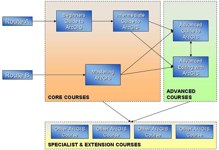
Each ArcGIS training course is designed to accommodate a different user level : from beginner through to advanced. Each course is designed to build on the knowledge gained from other courses so users can comprehensively develop their skills and experience by following a structured training path or by accessing any specialist course that suits their need.
For example our Beginners Guide to ArcGIS course is designed for users new to GIS or the ArcGIS software who wish to cover the core functions of the software. The Intermediate Guide to ArcGIS is designed to follow on from this course to develop each persons ability to utilise the spatial analysis functions and more challenging options that are on offer. The Advanced Guide to ArcGIS course is designed to go even further by dealing with complex techniques and advanced topics for manipulating and managing data.
There are also a number of special interest and application specific courses. For example a user might wish to focus on the huge array of functions that editing with ArcGIS offers or wish to create surfaces from point data using the specialist Spatial Analyst extension.
Modules
In addition to training courses, at GIS247 we also provide a large number of mini and super modules to support ArcGIS users.
 Mini modules are short presentations that cover a specific technical function, for example showing how to create summary statistics or georeference an image. Super modules are presentations that cover a larger topic area. For example, dealing with all aspects of creating and managing annotation or building and managing geodatabases.
Software & Versions
All courses and modules are suitable for v9.x/v10.x users. This includes users with an ArcView, ArcEditor or ArcInfo licence, whilst v10.x users will find support for ArcGIS for Desktop Basic, Standard and Advanced.
As not everyone is using the same version of the ArcGIS software we provide our full set of training courses and modules on the latest version (v. 10.3), but we also provide them on all previous versions (10.2, 10.1, 10.0, 9.3.1, 9.3, 9.2, 9.1, 9.0).
You might also like

Q&A

How difficult are IT training courses?
"These course can range anywhere from very easy to extremely difficult. Some factors that may have an effect on these are your own knowledge of computers, who is providing the course, how in-depth the course is and in some cases a persons age. These course are can be pretty simple as long as you take a small amount of time to familiarize your self with the terminology that will be used. Also if you are having difficulties talk with the staff or other students in the course and you may find other learning methods that will benefit you."


